

Table of Contents
- Why Cape Breton Is a Top Destination for Kayaking and Hiking
- Why Cape Breton Is a Top Destination for Kayaking and Hiking
- Best Kayaking Spots and Guided Tours on the Island
- Best Hiking Trails Mabou and the Cabot Trail Have to Offer
- Essential Coastal Paddling Safety Tips for Open Water
- How to Build Your Perfect Outdoor Adventure Itinerary
- Where to Stay: Base Camps for Adventure Seekers
- Common Mistakes to Avoid on Your Cape Breton Trip
- Final Thoughts: Start Planning Your Cape Breton Adventure
- Frequently Asked Questions
Last Updated: September 8, 2026
Why Cape Breton Is a Top Destination for Kayaking and Hiking
Why Cape Breton Is a Top Destination for Kayaking and Hiking
Cape Breton Island offers a rare combination of rugged coastline, highland trails, and protected waterways that makes kayaking and hiking a bucket-list adventure. Around Mabou, that means calm harbour and river paddling paired with some of the best hiking on the island, close enough together that you can be on the water in the morning and on a trail by afternoon. This guide from Northeast Cove Geodomes, in the heart of Mabou, covers the best routes, safety practices, and planning strategies.
What sets Cape Breton apart from other Canadian adventure destinations is the sheer concentration of accessible wilderness. The Cabot Trail loops 298 kilometers around the northern tip of the island, connecting coastal fishing villages with the Cape Breton Highlands. According to Parks Canada’s Cape Breton Highlands information, the national park protects old-growth forests, barrens, and more than 20 hiking trails ranging from short coastal walks to challenging backcountry routes. Few places let you transition so seamlessly between two distinctly different outdoor experiences.
Best Kayaking Spots and Guided Tours on the Island
Great sea kayaking exists all around Cape Breton’s exposed coastline, but the paddling at Northeast Cove Geodomes is all about what’s right outside the door: Mabou Harbour, which stretches four to five kilometers, and the Southwest Mabou River. There’s enough water here for a full week of different paddles, and several routes are already mapped out for guests:
- A paddle around the cove: A short, easy loop with excellent wildlife viewing, guests regularly spot blue herons, eagles, beavers, and a variety of other birds along the shoreline.
- Up the Southwest Mabou River: A longer route, roughly three hours round-trip, that winds through some of the most beautiful scenery in the area. Well worth the extra time for anyone comfortable with a longer paddle.
- Across the harbour to the marina: About a 30-minute paddle, followed by a five-minute walk to the Red Shoe Pub for supper and a beer or two before paddling back to the domes, a nice way to close out a day on the water.
- Out to West Mabou Beach or West Mabou Provincial Park: Paddle across the harbour and pull up at the beach, or continue to the provincial park to hike its trails before paddling back.
- A visit to the lighthouse: The lighthouse at the mouth of the harbour sits right where the working lobster and crab boats come and go, worth a paddle over just to watch the fishing fleet.

- A sunset paddle out to open sea: On calm days, guests can paddle out through the harbour mouth to watch the sunset from the open water before returning. This is the one spot on these routes where conditions can shift from sheltered to open-water fast, so check wind and tide before heading out through the mouth, and turn back if it’s picking up.
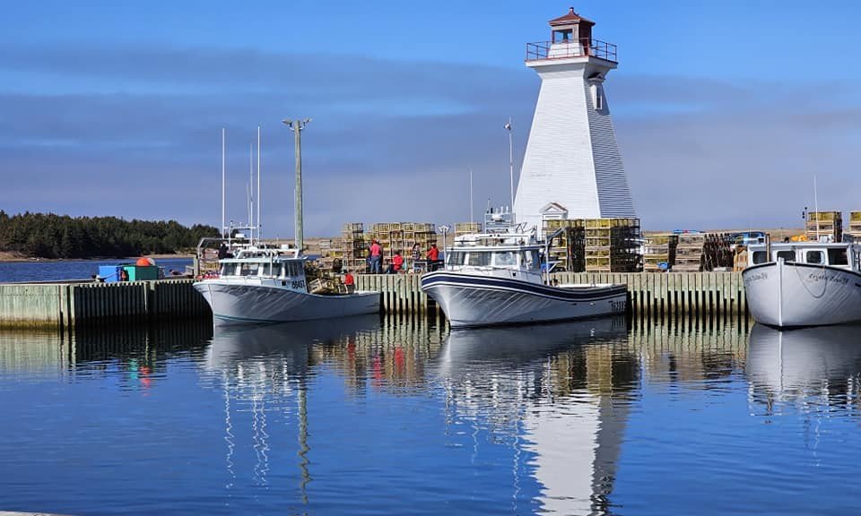
In the evenings, it’s also common to see people fishing striped bass right off the wharf, worth bringing a rod if that’s your thing.
Open-water sea kayaking along the sandstone cliffs and sea caves further down the coast is also a fantastic experience, but it’s a different undertaking from the harbour paddling described above: it requires a sea kayak (not the recreational kayaks provided on site), proper cold-water gear, and ideally a local guide. If sea kayaking is the goal, plan to bring your own sea kayak or book with a guided outfitter.
Best Hiking Trails Mabou and the Cabot Trail Have to Offer
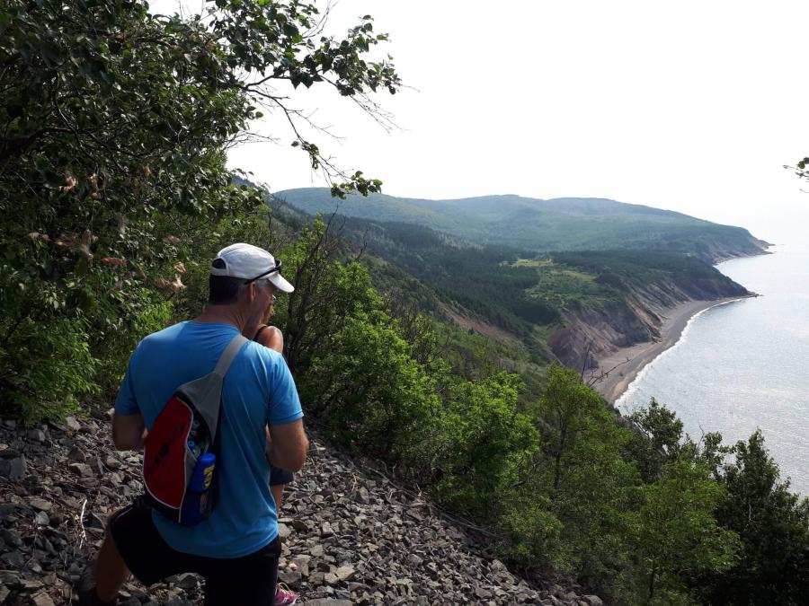
The best hiking trails Mabou has to offer are a short drive from Northeast Cove Geodomes, nowhere near the haul it takes to reach the Cabot Trail. The Cape Mabou Highlands Trail System is the closest of the bunch, about a 30-minute drive down Mabou Coal Mines Road to the trailhead: a roughly 30-kilometer network of about 17 marked trails, maintained by the volunteer Cape Mabou Trail Club since 1993, offering everything from short coastal walks to steep highland climbs with sweeping ocean views. Popular options include MacKinnon’s Brook Trail (about 4 km along shoreline cliffs), Fair Alistair’s Trail (a 3 km hike to a lookout, starting at the Mabou Mines trailhead), and Beinn Bhiorach, the “Steep Mountain” trail, a short but steep 1.8 km climb with views toward Prince Edward Island. Trailheads are reached via Mabou Mines Road and Cape Mabou Road.
For an easier outing, West Mabou Beach Provincial Park sits at the mouth of Mabou Harbour and combines a beautiful sandy beach with several easy, family-friendly trails through old farm fields, marshes, and spruce woods, good territory for spotting bald eagles, with views across to the Mabou Harbour lighthouse.
If you’d rather go flat and long, the Celtic Shores Coastal Trail is a 92-kilometer former rail bed running along the coast from Port Hastings to Inverness, passing right through the Mabou area. It’s flat, easy, and traffic-free, a good option for covering distance on foot or by bike without any real elevation gain.
Further north along the Cabot Trail, the Skyline Trail stands as the island’s most famous hike, and it’s well worth the drive if you have the time. This well-maintained path leads to a headland that drops sharply into the Gulf of St. Lawrence, with the option to continue down wooden boardwalks to a lower viewpoint. Trail difficulty varies widely across the park, so hikers should check elevation gain and distance before setting out. The Nova Scotia provincial hiking trail resources provide current conditions and difficulty ratings for the major routes, helping you match a trail to your fitness level and the day’s weather.
Essential Coastal Paddling Safety Tips for Open Water
Coastal paddling safety tips matter more in Cape Breton than almost anywhere else on the eastern seaboard, because the maritime climate can shift from calm to challenging within an hour. Check marine weather forecasts and tide charts before every launch, even on sunny days.
Note: The guidance below applies to open-water sea kayaking, not to paddling the harbour or river. If you’re using a recreational kayak on sheltered water, the biggest risks are wind and traffic, not tides, swell, or cold-water shock. This section is for anyone bringing their own sea kayak or joining a guided open-water tour.
Guests paddling from Northeast Cove Geodomes get an extra layer of reassurance: the property keeps a Zodiac-style rescue RIB on hand, and can send up a drone to check in on paddlers out on the water (and grab photos or video of the trip while they’re at it). It’s a nice option for anyone a little nervous about heading out, or for a family keeping an eye on less experienced paddlers.
Understanding Tides and Wind Before You Launch
The Bay of St. Lawrence and the Atlantic coast experience significant tidal swings, often exceeding 1.5 meters, creating strong currents in narrow channels and around headlands like those near Mabou. A common pattern is launching during slack tide and fighting a building current on the return. Consult the Canadian Hydrographic Service tide tables for your launch location. Prevailing westerlies can funnel through the Highlands, creating sudden gusts: a forecast of 15-knot winds can easily translate to 25-knot gusts in a narrow strait. If wind is forecast above 20 knots, choose a sheltered inlet or a Plan B activity.
The Essential Gear List for Cold-Water Paddling
Water temperatures in Cape Breton rarely climb above 15°C (59°F) even in August, and can drop to single digits in the shoulder seasons, making cold-water shock and hypothermia real risks. A properly fitted PFD is non-negotiable, but only the first layer of protection. A wetsuit or drysuit is a requirement for spring and fall paddling. Cotton has no place on the water; wear merino wool or synthetic base layers topped with fleece and a waterproof shell. Your PFD should have a whistle attached, and you should carry a waterproof VHF radio or personal locator beacon (PLB) in a dry bag within easy reach.
Filing a Trip Plan and Paddling with a Group
Before launching, always file a trip plan with someone on shore who is not going with you. Include your intended route, expected return time, the color of your kayak, and what you are wearing; this information is critical for search and rescue. Paddling solo in open water is high-risk; paddle with at least one other person. If you are new to the area, the safest option is a guided tour.
Watch Out: A common mistake is underestimating the combined effect of wind and current. These forces can push a kayak away from shore faster than most people can paddle back. If you find yourself being blown out to sea, do not exhaust yourself trying to paddle directly against the wind. Instead, paddle at an angle toward shore or a sheltered point, and use your VHF radio or PLB to call for help early.
Local Hazards: Fog, Swell, and Rocky Shorelines
Cape Breton’s coastline is beautiful but rugged and unforgiving. Fog is a frequent hazard, especially in June and July, and can reduce visibility to less than 50 meters in minutes, so you must be able to navigate by compass or GPS. Atlantic swell can be significant even on light-wind days, creating breaking waves over shallow reefs and rocky ledges. Always scout a landing site before committing; a beach easy to launch from at low tide may be a steep, rocky drop-off at high tide.
A Pre-Launch Safety Checklist
Before every paddle, run through this quick checklist:
- Check the marine forecast for wind speed, wave height, and fog probability.
- Check the tide tables for the time of high and low tide at your launch site.
- Tell someone on shore your exact route and expected return time.
- Wear your PFD and ensure it is properly fastened.
- Dress for the water temperature, not the air temperature.
- Pack your safety gear: whistle, VHF radio or PLB, spare paddle, tow line, and first-aid kit.
- Assess the conditions at the launch site. If the water looks rough or the wind is strong, have a Plan B ready.
By respecting the water and preparing for the worst, you ensure that your Cape Breton paddling adventure remains a highlight of your trip, not a safety incident.
How to Build Your Perfect Outdoor Adventure Itinerary
An outdoor adventure itinerary for Cape Breton should balance paddling days with hiking days, accounting for weather and your group’s energy levels. A sensible five-day plan starts with two consecutive kayaking mornings, when ocean conditions tend to be calmest, followed by a full-day hike on the Cabot Trail. The Cape Breton Island tourism planning guide recommends building in at least one flexible day, since heavy rain or high winds will force you to swap activities.
A Structured 5-Day Kayak & Hike Itinerary
The following plan is designed for a first-time visitor wanting a balanced experience of the west coast and the Highlands, using Mabou as a base for the first half and a national park campground or inn for the second.
Day 1: Arrival and Cove Paddle
- Morning: Arrive in Mabou and settle into your accommodation.
- Afternoon: Take a gentle paddle around the cove, one of the mapped routes available on site, to get comfortable with your kayak and spot some local wildlife along the way (blue herons, eagles, and beavers are all regulars).
- Evening: Paddle across the harbour to the marina (about 30 minutes) and walk five minutes up to the Red Shoe Pub for supper and a beer, then paddle back to the domes as the sun sets.
Day 2: The Southwest Mabou River
- Morning: Launch for the longer paddle up the Southwest Mabou River, roughly three hours round-trip through some of the most scenic water in the area.
- Afternoon: After lunch, rest up or take an easy walk at West Mabou Beach Provincial Park, or, if you have more energy, start into the Cape Mabou Highlands Trail System via Fair Alistair’s Trail for a shorter loop with a lookout.
- Evening: If conditions are calm, paddle out through the harbour mouth to watch the sunset from open water (check wind and tide first), or visit the lighthouse to watch the lobster and crab boats come in.
Day 3: Highland Ascent and Relocation
- Morning: Pack up and drive north on the Cabot Trail toward the Cape Breton Highlands National Park, allowing 1.5 to 2 hours for the scenic drive.
- Late Morning: Hike the Skyline Trail, a 9.2-kilometer loop taking 3-4 hours. The well-maintained trail offers dramatic views of the Gulf of St. Lawrence. Arrive early to secure parking, as this is the park’s most popular trail.
- Afternoon: Check into your accommodation for the next two nights, either a campground within the park or a lodge just outside its boundaries.
Day 4: A Full-Day Backcountry Hike
- Morning: Tackle a more challenging trail, such as the Franey Trail, a 7.4-kilometer loop with a steep 520-meter elevation gain rewarding you with panoramic views of the Clyburn River canyon and the Atlantic coast. Pack a full lunch, plenty of water, and extra layers.
- Afternoon: Descend and rest, or explore a shorter interpretive trail near your accommodation if you have energy.
- Evening: Attend a Parks Canada evening program or enjoy the dark skies for stargazing.
Day 5: Final Paddle and Departure
- Morning: Before heading home, enjoy one last calm paddle on a sheltered freshwater lake within the park, such as the one at Benjie’s Lake Trail, a different perspective from the harbour and river paddling earlier in the week.
- Afternoon: Begin your journey back, taking the scenic route along the western side of the island if time permits.
The ‘Plan B’ Principle: Weather-Dependent Alternatives
The single most important planning principle for Cape Breton is flexibility: high winds, fog, or heavy rain can make paddling unsafe, and trails can become slippery or closed after a storm. For every paddling day, have a land-based ‘Plan B’; for every hiking day, have a shorter, sheltered alternative.
- If it’s too windy to get on the water: The harbour and Southwest Mabou River routes are already sheltered, but if wind picks up even there, switch to a hiking day on a forested trail that is protected from the wind.
- If hiking is cancelled due to rain: Visit a local museum or cultural center, or take a scenic drive. The Cabot Trail is spectacular even in the rain, and many viewpoints are accessible directly from the road.
- If fog rolls in: Fog often burns off by late morning. Delay your launch or trailhead start by a few hours and use the time to visit a local bakery or coffee shop. If the fog persists, stick to well-marked, inland trails where navigation is easier.
Logistics: Getting Around Without a Personal Vehicle
A common question is how to manage gear and transportation between trailheads and launch points without a personal vehicle. While a car is the most convenient option, it is not the only one. Several tour operators offer multi-day packages that include transportation from a central hub like Mabou or Baddeck. These packages typically include kayak shuttles, so you can paddle a one-way route and be picked up at the end. For hikers, the Nova Scotia provincial hiking trail resources lists trailheads that are accessible by the local transit system, though service is limited. A practical alternative is to base yourself at a single location, like a lodge or a geodome resort, that offers complimentary kayaks and bikes. This eliminates the need to transport gear daily and allows you to launch directly from your accommodation. If you do drive, remember that the Cabot Trail’s winding roads mean a 50-kilometer drive can take over an hour, so factor that into your daily travel time.
Sample Day Structures for Different Pacing
For a less structured approach, consider these day structures:
- The Balanced Day: Morning kayak tour (2-3 hours), afternoon coastal hike (1-2 hours), best when both activities are based in the same area, like Mabou.
- The Epic Day: Full-day highland hike with packed lunch and extra layers, for experienced hikers covering 15+ kilometers and significant elevation.
- The Recovery Day: Morning paddleboard session on a calm inlet, afternoon exploring local villages and galleries.
- The Early Bird Day: Sunrise hike to beat afternoon heat and crowds, then a sunset paddle.
Keep each day’s totals realistic. Beginners should limit daily kayaking to roughly 10 kilometers and hiking to 8 kilometers with moderate elevation gain. Experienced adventurers can push these numbers, but always leave a buffer for unexpected delays or weather changes.
Where to Stay: Base Camps for Adventure Seekers
Choosing the right base camp transforms a good Cape Breton trip into an exceptional one. Mabou serves as an ideal hub because it sits within reasonable driving distance of both the western coastline and the Cabot Trail’s southern entrance. Northeast Cove Geodomes offers four private, waterfront geodomes designed for one or two guests, each with a fully equipped kitchenette, private ensuite bathroom, and climate control for cooler shoulder-season nights.
The property includes complimentary recreational kayaks, paddleboards, and bikes for paddling the sheltered harbour and Southwest Mabou River directly from the shore, so guests can get on the water without coordinating rentals or transporting gear. Several routes are already mapped out, from a quick wildlife-viewing loop around the cove to the half-day paddle up the river or across to the marina for supper at the Red Shoe Pub. (Guests wanting to sea kayak on the open coast will need to bring their own sea kayak or arrange a guided outfitter separately.) Wilderness camping is available throughout the national park for a more rustic experience, while glamping and boutique inns suit travelers who prefer a solid roof and warm bed after dark.
Common Mistakes to Avoid on Your Cape Breton Trip
The most frequent error visitors make is overpacking the itinerary, leaving no room for weather delays or rest days. Cape Breton’s maritime climate produces changeable conditions, and a rigid schedule will either exhaust you or force you to paddle in unsafe weather. Another common mistake is underestimating driving distances between trailheads and launch sites.
Gear choices also trip up many adventurers. Cotton clothing absorbs moisture and causes chilling, so synthetic or wool layers are essential. Hikers frequently arrive without adequate rain protection or bug repellent, both necessary during the summer months. Finally, some visitors skip guided tours thinking they can navigate unfamiliar coastline safely. For kayaking and hiking Cape Breton trips, hiring a local guide for at least the first day provides orientation, safety knowledge, and access to routes not obvious from a map.
Final Thoughts: Start Planning Your Cape Breton Adventure
Cape Breton rewards those who plan thoughtfully, since the island’s best experiences require coordinating weather windows, tide schedules, and trail conditions. Most visitors leave already planning their return trip.
For a comfortable base that puts you steps from the water, Northeast Cove Geodomes provides the amenities that make multi-day adventures sustainable: climate-controlled accommodations, kitchen facilities for meal prep, and complimentary water sports equipment. The family-owned property has maintained consistently high guest ratings, with hosts Danny and Lorna known for their responsiveness and local knowledge. Book now to secure dates for the upcoming season.
Frequently Asked Questions
Where is the best place to kayak in Cape Breton Island?
For most visitors, Mabou Harbour and the Southwest Mabou River offer the best combination of scenery and easy, beginner-friendly paddling. At Northeast Cove Geodomes, guests can choose from several mapped routes: a short loop around the cove for wildlife viewing (blue herons, eagles, and beavers are common sights), a longer three-hour paddle up the Southwest Mabou River, or a half-hour crossing to the marina followed by a short walk to the Red Shoe Pub for supper. If you want open-water sea kayaking along the more exposed coastline, that’s a great experience too, but you’ll need to bring your own sea kayak or book with a guided outfitter, since it’s a different kind of paddling than the recreational kayaks provided on site.
What is the best hike on Cape Breton Island?
The Cape Mabou Highlands Trail System, about a 30-minute drive down Mabou Coal Mines Road, is the local favorite: about 30 kilometers of trails ranging from easy coastal walks to steep highland climbs, with options like Fair Alistair’s Trail and Beinn Bhiorach (Steep Mountain) delivering big views for a fraction of the drive it takes to reach the Cabot Trail. For an easier outing, West Mabou Beach Provincial Park pairs a sandy beach with gentle family-friendly trails. If you’re willing to drive north, the Skyline Trail in Cape Breton Highlands National Park is the most famous hike on the island, a relatively easy trail leading to a dramatic headland with panoramic ocean views and excellent whale-watching opportunities. Check trail difficulty and conditions before you go, wherever you choose.
Can I combine kayaking and hiking in a single day trip?
Yes, and it’s one of the best ways to experience the landscape. A practical approach is to paddle in the morning when the water is often calmer, then hike a shorter inland trail in the afternoon. The Mabou area works well for this, with launch points near trailheads. Keep your day flexible and check the marine forecast first.
What is a good itinerary for a 3-day trip to Cape Breton?
Base yourself in one central location like Mabou to minimize driving. Day one: paddle the harbour, and pick a mapped route based on how much time you want on the water. Day two: hike the Cape Mabou Highlands Trail System, about a 30-minute drive down Mabou Coal Mines Road, or drive further north for a section of the Cabot Trail if you’d rather see the highlands. Day three: paddle up the Southwest Mabou River or across to the marina for lunch. This structure balances activity with downtime.
Do I need to bring my own kayak and hiking gear?
Not necessarily, for harbour and inlet paddling. Some accommodations, including Northeast Cove Geodomes, offer complimentary recreational kayaks, paddleboards, and bikes for guests to use on the sheltered water right off the property. If you want to go sea kayaking on the open coast, however, you’ll need to bring your own sea kayak or book with an outfitter, since that’s a different boat and a different level of gear than what’s provided on site. For hiking, you should bring your own sturdy footwear, weather layers, and a daypack.
What should I pack for a multi-day outdoor adventure?
Layering is essential due to the maritime climate. Pack a waterproof outer shell, a warm mid-layer, and quick-drying base layers. Sun protection, insect repellent, and a refillable water bottle are necessities. For kayaking, bring a change of clothes in a dry bag. For hiking, a map, compass or GPS, and a headlamp are smart additions, even on popular trails.


